Deer Park
History:
Deer Park used to be referred to by the First Nations people as “Mushquoteh”, which means a meadow or opening in the wood where deer come to feed. In 1837, the Heath family purchased forty acres of land in “Mushquoteh”. Appropriately, they named their estate Deer Park.
By the 1850’s, the Deer Park area had grown to include a handful of country villas, a general store, a school, a cemetery, a race track, and a hotel that was located at the intersection of Yonge and St. Clair. Patrons at the Deer Park Hotel used to delight in feeding the deer that roamed on the hotel grounds.
The deer were long gone by the time Deer Park was annexed to the City of Toronto in 1908. Deer Park filled in very quickly after annexation. By the 1930’s the Deer Park neighbourhood was established as one of Toronto’s finest residential districts.
Overview:
Deer Park’s residential streets spill out onto either Yonge Street or St. Clair Avenue, right into the heart of one of Toronto’s busiest shopping, entertainment, and business districts.
Deer Park’s commercial centre provides a good balance for this neighbourhood which is surrounded by lush green parkland, majestic trees, and the Vale of Avoca Ravine.
Lifestyle:
The Yonge and St. Clair shopping district is known for its many fine restaurants. The high profile retailers in this area attract shoppers from all over the city.
Most of the local staple and grocery stores are located inside the St. Clair Centre and The Towne Mall or at the Delisle Court.
Homes:
Deer Park has a wonderful mix of detached and semi-detached houses that encompass a variety of architectural styles. Most of the original Deer Park houses were built between 1875 and 1920. Deer Park also contains a fair number of newer townhouses that blend in well with the older homes in the neighbourhood.
Deer Park has one of the largest selections of luxury condominium apartment buildings in Toronto. Most of these apartments have balconies with picturesque views of the park, the ravine or the city.
Recreation:
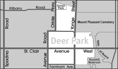
The Rosehill Reservoir located just steps from Yonge and St. Clair at 75 Rosehill Ave., is one of Toronto’s prettiest greenspace. Together with David Balfour Park this is an oasis in the bustling midtown core. The Rosehill Reservoir which forms the upper tier of this park includes a very pretty four acre reflecting pool lined with cobblestones. There is also an adjacent waterfall with a small bridge and a maze of stairs on each side, as well as a separate water fountain feature with a dramatic overhead spray that rushes water into the oval pool below. There is also a pretty flower garden and wading pool tucked away at the far end of the park.
Wrapped around Rosehill Reservoir is David Balfour Park that features a surfaced path that’s ideal for walking, jogging and cycling. This well treed park has a large children’s playground. Sign markers on the east side of the park indicate access points to the Vale of Avoca Ravine which includes a hiking trail that follows the path of an adjacent meandering creek. The urban forest and all the nature it nurtures is remarkably vibrant, and a pleasant surprise given the proximity to such a well established urban area.
Oriole Park located at the northern tip of Deer Park has a playground, a wading pool, two tennis courts and access to the Belt Line’, a seven kilometre path that follows the route of Toronto’s old Belt Line Railway. Oriole Park is also home to the newly created Neshama Playground. The Neshama Playground features a water play area, sensory musical features, Braille panels, an enclosed climbing merry-go-round and bounce pad, accessible swings and play structures, and colourful, springy surfacing.
Transportation:
The St. Clair subway station is within walking distance of every home in Deer Park.
Motorists are approximately ten minutes from downtown, and twenty minutes from Toronto’s Expressways and Highways.
Featured Listings
Deer Park Stats
Walkability:
High
Bikeability:
Medium
Public Transit:
High
Affordability:
Low
Greenspace:
High
Recreation:
High
Legend: Low, Medium, High
Commute Times
* All commuting times provided are approximate times only. Commute times may increase or decrease depending on where you live within the neighbourhood and the time of day i.e rush hour versus off hour commutes. Time estimates to public transit are based on walking distance or bus line connection whichever is quicker. All other commute times on the chart above are based on drive times.
School Guide
No Records Found
Sorry, no records were found. Please adjust your search criteria and try again.
Google Map Not Loaded
Sorry, unable to load Google Maps API.
Toronto School Resources

Editor’s Note. BEFORE MOVING INTO, BUYING OR RENTING A HOME, PLEASE CONTACT THE SCHOOL YOU ARE CONSIDERING BY PHONE to ensure your home is within the designated boundaries and that your child is age appropriate. WE CANNOT BE HELD RESPONSIBLE FOR ANY MISINFORMATION REGARDING SCHOOL ENROLLMENT SO DO NOT ASSUME that your child can automatically attend a specific school or specialized program until you have official confirmation from that school. Please visit the school board web sites for more information.